Digital Twin & Measured Surveys
Digital Twin & Measured Surveys
LiDAR-powered building capture using Matterport Pro3, delivering accurate digital twins, point clouds, CAD drawings and BIM-ready outputs.
Priced per project — tell us about your building and we will confirm scope, outputs and delivery.
“I have been dealing with Photoplan for 20+ years. They always provide a speedy and efficient service, with photos and floor plans that do real justice to the property we are marketing.”
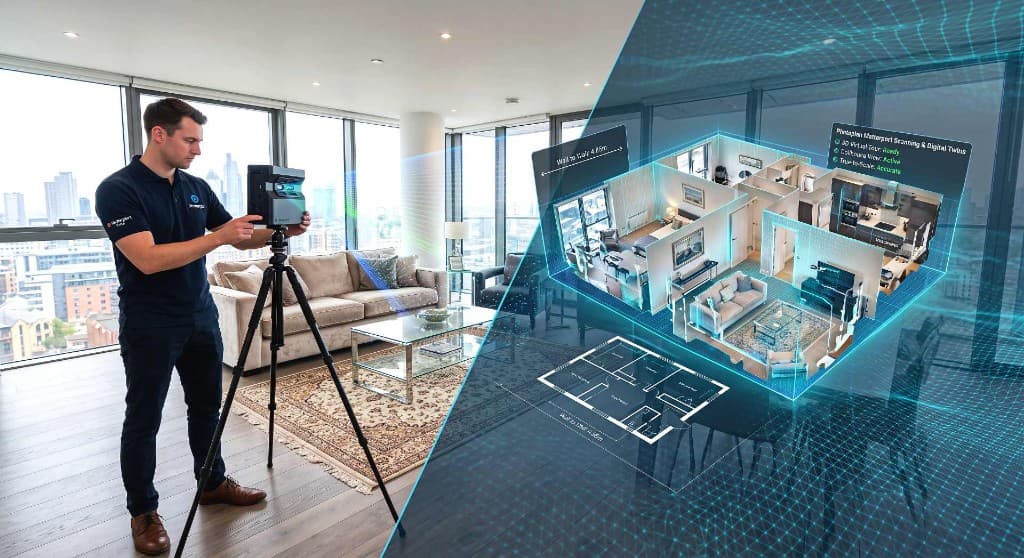
Explore a real Matterport Pro3 digital twin — walk through the space, switch to dollhouse view and review layout remotely. The same capture workflow powers our measured survey and point cloud outputs.
Survey-grade capture
Digital records built for design and documentation
Photoplan captures buildings with Matterport Pro3 LiDAR technology — delivering interactive digital twins, point clouds and measured survey outputs for architects, developers, landlords and facilities teams across the UK.
- 2004
- Established
- 22+ yrs
- Industry experience
- Pro3
- Matterport LiDAR
- UK-wide
- Nationwide coverage
- E57
- Point cloud delivery
- CAD & BIM
- Survey outputs
- Commercial
- Offices & estates
Photoplan captures buildings using Matterport Pro3 LiDAR technology to create accurate digital records for planning, design, documentation and asset management. From commercial offices and retail units to large estates and refurbishment projects, we deliver the spatial data and survey outputs your team needs — with survey-grade workflows where required.
- Pro3
- Matterport LiDAR
- E57
- Point cloud export
- UK-wide
- Nationwide coverage
What you get
Everything done properly
Professional capture, expert finishing and reliable delivery — every time.
Pro3 LiDAR capture
Highly accurate LiDAR-based capture on site — typically completed in a single visit.
Interactive digital twin
Explorable 3D model with walkthrough, dollhouse view and remote access for project teams.
Point cloud delivery
E57 point cloud files exported for CAD, BIM and point cloud software workflows.
CAD & BIM outputs
Measured floor plans, survey drawings and BIM-ready deliverables scoped to your brief.
How it works
From booking to delivery
- 1
Brief & scope
Tell us about the building, intended use and required outputs — we confirm scope, pricing and delivery.
- 2
On-site Pro3 capture
A Photoplan specialist scans the property with the Matterport Pro3 LiDAR camera.
- 3
Digital twin processing
Capture data is processed into an interactive digital twin and spatial record.
- 4
Point cloud / CAD / BIM outputs
E57 files, measured drawings and BIM-ready deliverables are prepared to your specification.
- 5
Delivery and support
Files and hosted links are delivered with guidance on access, formats and next steps.
Who it is for
Built for property and construction professionals
Digital twin measured surveys sit above standard listing floor plans — designed for teams who need accurate spatial data, documentation outputs and a reusable record of the building.
Architects
Existing condition records, as-built data and spatial context for design and planning.
Developers
Accurate base surveys for refurbishment, conversion and fit-out programmes.
Commercial landlords
Portfolio records, lease documentation and tenant handover packs.
Facilities managers
Asset registers, maintenance planning and remote site access for dispersed teams.
Interior designers
True-to-scale layouts and room data to inform space planning and specifications.
Construction teams
Site documentation, progress records and coordination data for live projects.
Heritage and listed buildings
Non-invasive capture that documents fabric, layout and condition for sensitive sites.
Education and public sector estates
Campus-wide records, space utilisation data and documentation for large estates.
What we can deliver
Outputs tailored to your project
Every commission is scoped to the outputs your team needs — from a digital twin and point cloud through to CAD drawings, measured surveys and BIM-ready deliverables.
Matterport Pro3 LiDAR capture
On-site scanning with the latest Pro3 camera — indoors, across multi-floor buildings and suitable for many exterior areas.
Interactive digital twin
A hosted, explorable 3D model with walkthrough, dollhouse view and measurement tools for remote teams.
E57 point cloud files
Survey-grade point cloud data exported for use in CAD, BIM and point cloud software.
CAD floor plans
Measured floor plans drawn from scan data — suitable for design, space planning and documentation.
Measured building survey drawings
Existing condition layouts and elevations where required, aligned to your project brief.
Revit / BIM-ready outputs
Model-ready data and drawings to support BIM workflows — scope agreed at quotation stage.
Existing condition records
A dated, accurate record of the building as found — useful for refurbishment and dilapidation.
Site documentation
360 imagery and spatial context captured in a single visit for planning and stakeholder review.
360 walkthroughs for remote teams
Shareable links so architects, contractors and clients explore the space without repeat site visits.
The technology
Why Matterport Pro3?
We capture with the Matterport Pro3 — a LiDAR-enabled camera that records geometry, imagery and spatial context in one workflow. The result is a highly accurate LiDAR-based capture suitable for many measured survey and existing condition documentation projects, with survey-grade workflows where required.
This is a higher-value service than standard estate agency floor plans. Where marketing plans prioritise speed and layout clarity, digital twin measured surveys deliver the depth of data architects, designers and commercial teams need for serious documentation work.
Explore Matterport scanning- LiDAR capture for highly accurate spatial data
- Fast on-site scanning — typically a single visit
- High-quality 360 imagery alongside depth data
- Accurate room dimensions and building geometry
- Remote viewing for distributed project teams
- Useful for refurbishment, design, planning and asset management
Use cases
Where digital twin surveys add value
From single commercial units to multi-building estates, LiDAR capture creates a reusable record that supports design, documentation and asset management long after the site visit.
Refurbishment projects
Capture the building as found before strip-out and design — giving your team a reliable base for measured surveys and coordination.
Commercial property records
Maintain an accurate digital record of offices, retail and industrial units across a portfolio.
Architecture and design
Feed existing condition data into concept design, planning submissions and stakeholder presentations.
Space planning
Understand room sizes, circulation and adjacencies before committing to layouts and furniture schedules.
Facilities management
Support maintenance programmes, contractor briefings and remote inspections with a living building record.
Dilapidation and condition records
Document condition at lease start or end with spatial context alongside measured layout data.
Large estates and portfolio capture
Roll out consistent capture standards across multiple buildings, campuses or regional portfolios.
Construction progress documentation
Record milestones and site conditions at key stages — useful for reporting and dispute resolution.
Choosing the right service
Estate agency floor plans vs digital twin measured surveys
Both have a place. Standard floor plans are ideal for listing marketing; digital twin measured surveys are for teams who need point cloud data, CAD outputs and a documentation-grade record of the building.
| Feature | Estate agency floor plans | Digital twin measured surveys |
|---|---|---|
| Primary purpose | Property marketing | Design & documentation |
| Capture method | Laser measure on site | Matterport Pro3 LiDAR |
| Turnaround | Fast — often next day | Project-scoped delivery |
| Layout detail | Clear approximate layout | Higher-detail spatial capture |
| Point cloud data | ||
| CAD / BIM outputs | ||
| Interactive digital twin | ||
| 360 remote walkthrough | Optional add-on | |
| Typical audience | Estate agents & vendors | Architects, FM & commercial teams |
Need a marketing floor plan instead? See our floor plans service or 3D floor plans.
Explore more
Related services
Digital twin measured surveys often sit alongside Matterport tours, measured floor plans, lease plans and 360 walkthroughs — we can scope a combined visit where it makes sense.
Frequently asked questions
Need a digital record of your building?
From commercial spaces and offices to large estates and refurbishment projects, Photoplan can capture your property using Matterport Pro3 and deliver the outputs your team needs.